
| Site IB-01 | |||
|---|---|---|---|
| Time Frame | BIBI (Condition) | FIBI (Condition)a | RBP (Condition) |
| 2024 Results | 2.71 (Poor) | 1.00 (Very Poor) | 99 (Non-Supporting) |
| Cumulative Average (2017-2024) | 2.89 (Poor) | 1.58 (Very Poor) | 109 (Partially Supporting) |
| 3-year Running Average | 2.52 (Poor) | 1.45 (Very Poor) | 103 (Partially Supporting) |
a) fish data were collected 2018, 2020, 2022, and 2024.
Site IB-01: IB-01 received a BIBI score of 2.71 (Poor) in 2024, the third consecutive year with a score below 3.00 after four years (2018-2021) of scoring 3.00 or higher. The cumulative average BIBI score is 2.89 (Poor) while the three-year running average is 2.52 (Poor). True flies have been the dominant organism in samples over the past five years.
IB-01 Summary of Insects Collected by Sample Year:

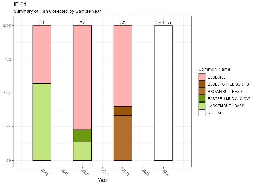
Site IB-01: The site received either a “Poor” or “Very Poor“ rating in previous years, as the number of individual fish found at this site has been relatively low. In 2024, no fish were found at the site, resulting in an automatic score of 1.00 (Very Poor).
IB-01 Summary of Insects Collected by Sample Year:
Site IB-01: The 2024 RBP score of 99 (Not Supporting) is lower than typical scores dating back to 2018 which have correlated to “Partially Supporting” or “Supporting” ratings. The cumulative average and the three-year running average scores are both in the Partially Supporting category at 109 and 103, respectively.
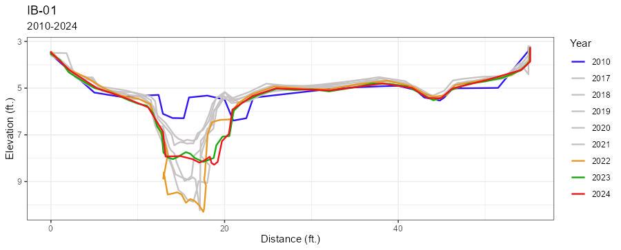
Site IB-01: A geomorphological assessment was performed here in 2010, as part of a separate project and before yearly assessments began in 2017. Between 2010 and 2022 the channel incised by nearly 4 feet, indicating increased peak flows and little interaction between the stream and surrounding floodplain. A collapse of the right bank between the 2022 and 2023 measurements resulted in a 3-foot retreat of the right bank and the deposition of 2 feet of sediment on the channel bottom. The 2024 measurement showed little change from the previous year.
IB-01 Cross-Section Comparison:
| IB-01 | |||
|---|---|---|---|
| Year | BIBI (Condition) | FIBI (Condition) | RPB (Condition) |
| 2017 | 2.43 (P) | --- | 138 (S) |
| 2018 | 3.29 (F) | 2.00 (P) | 104 (PS) |
| 2019 | 3.29 (F) | -- | 117 (PS) |
| 2020 | 3.00 (f) | 1.67 (VP) | 104 (PS) |
| 2021 | 3.57 (F) | -- | 102 (PS) |
| 2022 | 2.71 (P) | 1.67 (VP) | 106 (P |
| 2023 | 2.14 (P) | -- | 103 (PS) |
2024 | 2.71 (P) | 1.00 (VP) | 99 (NS) |
| Station Summary | ||||||
|---|---|---|---|---|---|---|
| Average BIBI (SD) | 3-Year Average BIBI (SD) | Average RPB (SD) | 3-Year Average RBP (SD) | Average FIBI (SD) | 3-Year FIBI Average (SD) | |
| IB-01 | 2.89 (0.48) | 2.52 (0.33) | 109 (13) | 103 (4) | 1.58 (0.42) | 1.78 (0.39) |